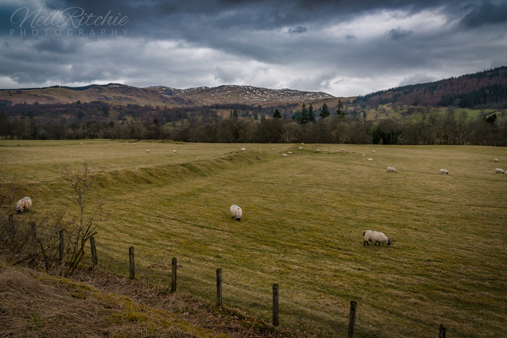
Scotland is truly fortunate in the number and range of Roman marching camps already identified here, and without a shadow of doubt, many more remain to be discovered in the years to come.
Marching camps are found across the entire Roman Empire, but for some reason, Scotland has more of these – and of the most varied examples of this particular type of fieldwork – known anywhere in the world.
These temporary bivouacs are known as “marching camps” as it is usual to consider their classic role as providing an entrenched and ordered encampment for a force on the march.
Ancient sources tell us how – like a well-oiled machine – the leading elements of a Roman force could rapidly mark out the proposed site (the task of surveyors – the Mensor or Gromatici), dig the enclosing ditch, and form the rampart of a marching camp even as the tail end of a large marching column was still coming up.
Smaller temporary camps were employed by groups employed building forts as well as undertaking engineering works such as constructing roads and frontier installations and the size of these camps can vary enormously.
The ancient military manuals of Vegetius, Hyginus, and Polybius describe the regulation ditch; a “fossa legitima” with dimensions that varied on a sliding scale between five feet wide by three feet deep to some seventeen feet wide by nine feet deep.
The profile of the ditch (illustration No. 1) was generally a symmetrical inverted triangle, with a continuous square slot running along the bottom.
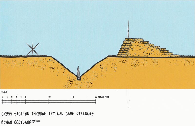
A rarer ditch profile was the “Punic” ditch which had slopes of differing pitches. The outer counterscarp had an almost vertical face while the inner scarp had a very gentle slope. This arrangement has been described as a man trap feature for attackers caught within the ditch cordon and stuck in missile range unable to escape. A more probable reason is that the gentler inner slope allowed easy supervision of the bottom of the ditch from the rampart.
The purpose of the slot at the base of Roman ditches has generated much speculation and is usually described as a drainage slot or an “ankle breaker” defensive feature.
Neither is a particularly satisfactory explanation. A drainage slot, to function, needs somewhere to conduit water to. The continuous circuit of a defensive ditch does not provide such an outlet and groundwater, waste, mud and probably excrement would have swamped the bottom of any ditch before long regardless of whether it had the square slot at its base or not.
The “ankle breaker” is a superficially attractive suggestion, however, the main casualties of such a feature would be the ankles of the Roman soldiers involved in digging these ditches. The very last thing a Roman commander would have wanted was for his valuable and hard marching assets- the Roman soldiers themselves to be laid up through an epidemic of ankle injuries each and every time a camp is formed.
The mysterious slot was most likely used to seat obstructions in the base of the ditch, much as was done in the rationalised fortifications of the European early gunpowder era. Sharpened stakes, thorn bushes, and other similarly unpleasant nasty surprises would have been seated in the slot and packed tight with turves or anything else to hand, an ancient equivalent of barbed wire all now long decomposed.
The rampart – it was not a major affair – was formed from the excavated spoil from the ditch. It is possible that it may have been faced with turves while the ditch spoil itself was restrained in the middle to prevent the first good Scottish summer rainstorm washing the whole affair away back into the ditch.
The soldier’s campaign stakes could be utilised in a variety of ways. Experimental reconstructive archaeology shows they could- if sufficient were available- be thrust into the top of the rampart mound and lashed together to form a continuous breastwork, or three could be lashed together to form a large spiked caltrop device, a continuous hedge of which could be extremely rapidly deployed along (or even outwith) the rampart embankment as work progressed and importantly equally quickly dismantled at the time to break camp and resume the onward march.
A felled robust sapling could have a series of pairs of these stakes lashed to it as cross spars, functioning as a perfectly adequate movable barrier at the camps gateways. Depending on the size and date of the camp there could be between four and six of these entrances. Each soldier we are told carried two of these stakes.
Two main forms of a camp gateway are known. The most commonly encountered is the “titulm” or traverse, a short length of rampart and ditch placed in an advanced position beyond an opening left in the main defensive circuit. A rarer form is the “clavicula” gateway. This had quarter-circle extensions of the rampart mound internally and externally, the external portion having a corresponding length of ditch to its front. There are variations in the form of the clavicula type but the basic principle allowed what appears to have been a strengthened gateway that exposed any attacking tribesmen’s right-hand side (not his shield side) to missiles discharged from the inner curved rampart.
Why clavicula gateways appear more in Scotland than elsewhere is not immediately clear, perhaps the famous storming of the Ninth Legions camp in Scotland in 82 AD with much of the ensuing fighting taking place reportedly in the gateways inspired some later Roman officers in charge of camp construction – the Praefectus Castrorum – to utilise this stronger gate feature.
The type of camp utilising clavicular gates are known as Stracathro types, named after the site in Angus where the feature was first identified.
Internally the camp was laid out with a gap, called the intervallum, some sixty feet wide maintained between the rear of the rampart and the start of the orderly set out tent lines. As well as allowing space for troops to be marshaled the distance was also carefully calculated to keep the tents out of the range of missiles thrown in from outside the camp, particularly at night when an enemy may attempt to creep quite close to the ditch under cover of darkness. However, we should expect the Romans to have deployed pickets in advanced positions, their positions as well as the key points in the ramparts well lit by braziers.
The particular simple genius of the Roman marching camp was that the fundamental layout of the camp never varied to any great degree. Internally the camp was subdivided into the constituent elements shown on illustration No. 2, a sure way of assisting soldiers arriving late, or those roused after dark to undertake their sentry duties, or in an emergency. A soldier would automatically know where he was and where to go or to search for any constituent element of the campaign force.
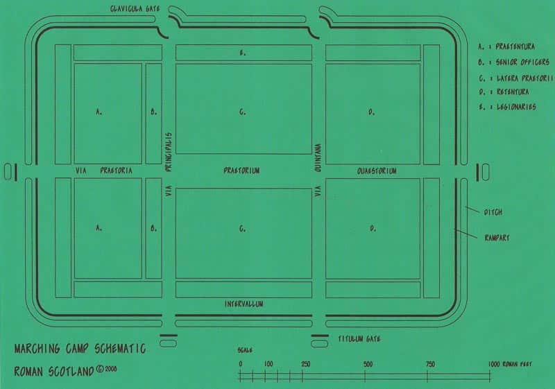
The camp was subdivided by “streets” and the most important ones had a pronounced “T” shape and focussed on the commander’s pavilion: the Praetorium. The Via Principalis, as its name suggests was the main road and passed from the front to back of the camp along the face of the Praetorium. Running perpendicular to this road from the Praetorium was the Via Praetoria. Behind the Via Principalis and parallel to it ran the Via Quintana and this ran to the third pair of gates in the defences.
Lesser streets will have further split the intervening blocks of land between these main thoroughfares allowing access to the individual units bivouacs. The block of ground fronting the Via Principalis was known as the Praetentura, the middle block between the Via Principalis and the Via Quintana was known as the Latera Praetorii while the last block was termed the Retentura.
Hyginus`s military manual advised that the legionary bivouacs should be placed near to the defences within these blocks while the evidently less reliable auxiliary – or more probably allied – troops were placed further into the camp. We should not therefore automatically assume the Praetentura, the Latera Praetorii and the Retentura housed distinct unit types, the troops would have been dispersed throughout them.
Such diagrams, however, are the ideal, the terrain at each site will have dictated minor revision or alteration to the standard layout as will the circumstances of the particular field force, its baggage, and any livestock and heavy equipment accompanying the troops. Little Clyde near Crawford for instance is bisected by a stream running in a gully, while the mammoth camps of Severus, where possible are located on advantageous high ground, their ramparts often twisted to suit the contour of the slope, particularly in Southern Scotland where defence appears to have been a prime consideration.
We are told latrine pits were dug but the standard layout does not advise where these were, though probably near the ramparts. A position at a lower gradient if the camp is on sloping ground -difficult to avoid given the size of most camps- and downwind while away from water sources would seem the most logical location.
Marching camps for armies on a campaign can be vast, among the largest known in the Roman Empire are the massive 160 acre sites in Southern Scotland, likely to belong to the Maetae campaign of Emperor Septimus Severus in 209 AD. This area is capable of accommodating upwards of 40,000 men including their heavy equipment. Such powerful battlegroups make a mockery of fashionable theories from the 1970s onwards which improbably consider ancient Scotland as proving no military threat to the Romans who in turn they allege were merely concerned with undertaking and controlling trade with the locals! Complete nonsense of course.
Temporary camps, due to the short periods of occupation are not noted for producing large amounts of dateable artefacts. There have however been several signal discoveries of dateable pottery and coins -or indeed the incredible tally of bread ovens uncovered recently at Kintore- which help to date a camps likely period of use.
Also at some locations, the context of the camp’s relationship with other more readily dated Roman features on the site; under or overlying a fort or road for instance can assist to a degree in giving either a terminal start or end date for the camps probable period of use.
Marching camp morphology; it is considered that camps with a fairly square or only slightly elongated plan are earlier (in the Scottish context Flavian) while later camps tend to take a more elongated form. Camps attributed to Severus can be massive and their plans can exhibit acute rampart returns at corners and misalignment between sections of the defences on either side of gateways. Clavicula gateways appear in general to be a Flavian device, and may possibly post date Agricolas tenure or belong- as noted above- as an innovation in Scotland at least to his last campaigning season at the earliest.
A camp could be reduced in size, either as a battlegroup split or on a sites later re-use by a smaller force. Temporary camps for some reason never appear to have been enlarged. In general, however, the Roman soldier usually seems to have been employed setting up his camp from scratch, an occurrence not unreasonably attributed to military dogma: that it was easier for the troops to do what they had trained to do from scratch in preference to altering an existing layout, something which at the end of the day may have ended up taking longer.
Some later camps, as at Ardoch in Strathearn notably overlie earlier camps and it is axiomatic that in order to prevent the vestiges of the earlier camps defensive features greatly hampering the layout and communication within the later camp that a considerable period of time must have elapsed between the abandonment of the earlier camp and the foundation of the later allowing the formers earthwork defences to have eroded through weathering.
Marching camps are always located at a fordable river or stream allowing the supply of drinking water. Often camps seem to be located at the junction of two watercourses, a practice which probably increases the site’s strategic strength, improves the site’s connection to navigable waterways where supplies are likely to have been brought up as well as improving the quantity and quality of the drinking water available given the rapidity with which a single watercourse would have become fouled.
While permanent forts often seem to be located before a river crossing, marching camps on the other hand often appear to have been located beyond a river crossing, suggesting that Roman troops ended their day’s march as often as not with wet feet.