During an environmental check before harvesting in Glen Brittle Forest on the Isle of Skye, the low stone walls and earthen banks of a post-medieval township were discovered.
The township is believed to date back to the 17th and 18th centuries and is made up of various types of buildings, including houses, byres, barns, and corn-drying kilns. The buildings were found within a mature conifer plantation that is mostly made up of Sitka spruce trees that were planted in 1977. Due to windblown trees, many sites were partially hidden.
Forestry and Land Scotland recently commissioned AOC Archaeology to conduct a comprehensive survey. Before beginning their fieldwork, the archaeologists examined historical records. They discovered that the township was named Brunell on an early 19th-century map, surveyed by John Thomson in 1832.
They also reviewed the Old and New Statistical Accounts for the Parish of Bracadale on Skye. Although there was no specific information about the township, they found general descriptions of life in the parish.
“the parish produces black cattle, sheep and horses. Black cattle is the main staple… from the returns of which the people pay their rents and supply themselves with necessities. There are small quantities of sheep on each farm, but there is no farm laid out entirely to sheep pasture” (Bracadale, County of Inverness, OSA, Vol. 22, 1792).
Almost 50 years later, the minister reported that “at the time of the last [Old] Statistical Account, the population was 2250 souls. By the last census it was 1769, and since that period there has been a farther decrease. This decrease is solely to be ascribed to the system of farming which has for some time been adopted: throwing a number of farms into one large tack for sheep-grazing, and dispossessing and setting adrift the small tenants” (Bracadale, County of Inverness, NSA, Vol. 14, 1840).
This was the fate that lay in store for the inhabitants of Brunell. The township was deserted by the time of the first Ordnance Survey, who depict only two unroofed buildings and a field on their map from 1881.
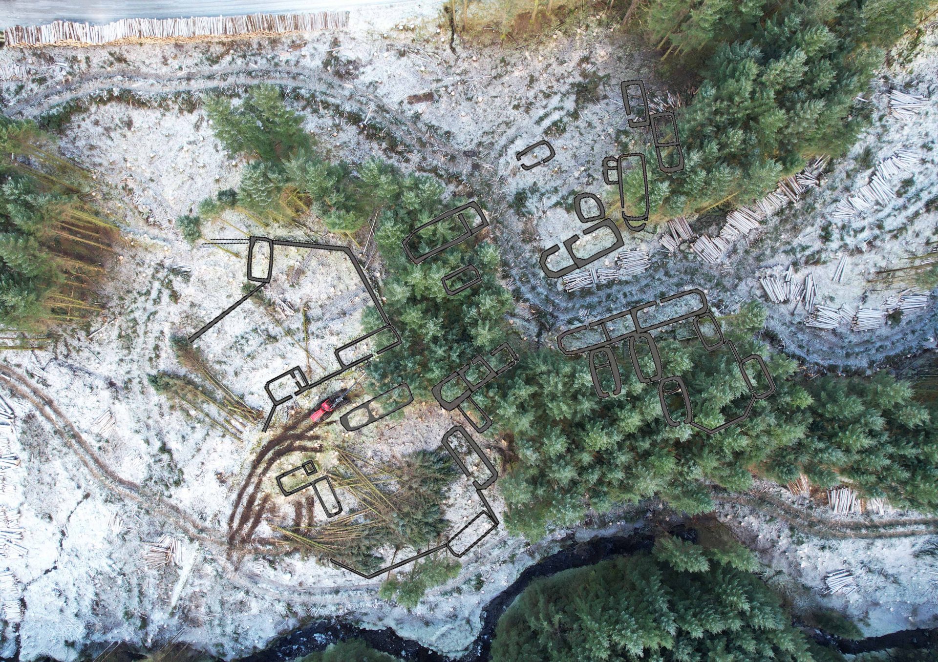
The recent archaeological survey recorded twenty-eight buildings that were clustered together with fields and stock enclosures to form a small township. The township was situated on terraces on the north side of the Allt Dabhoch burn.
The survey was used to plan and deliver a clear fell operation by Highland Timber Harvesting on behalf of Tilhill. First, the individual buildings were marked out on the ground. The machine operators then used their skill and experience to carefully plan the harvesting operation. They used short tracks to move around the township and felled trees into open spaces, away from the buildings to avoid causing any damage.
On the bird’s eye view of the harvesting process taking place in and around the township the location of the buildings has been marked on the image. Some buildings are visible as they are located in cleared areas, while others are still hidden under the trees.
You can observe how the harvester operates between the buildings, using short tracks to move around the township with ease. The harvester carefully fells trees and removes them from the buildings, placing them in open spaces for processing into logs.
Once ready, the logs are neatly stacked and removed by the forwarder. The forwarder follows the same tracks to transport the logs to the roadside, where they are loaded onto timber lorries.